There are “wonders” on the back roads of northern Ontario.
Too many.
The original idea for the Seven Wonders of the World evolved from a list of ancient architectural and natural marvels compiled by Hellenic travellers
Last week, we looked at Northern Ontario through the lens of tourism on a macro scale. It was a main roads theme, not so much the back roads.
For the second part of this two-part series, we explore seven heritage wonders of Northern Ontario on the back roads. The word heritage allows for human-created and natural sites. The challenge in compiling the list we will explore in this column was to try and whittle it down to a lucky number seven list.
How a site becomes a 'wonder'
AI tells us, “The initial list evolved to a global list of both ancient and contemporary landmarks, chosen through public voting.”
The seven traditional wonders are the Great Pyramid of Giza, the Colossus of Rhodes, the Lighthouse of Alexandria, the Mausoleum at Halicarnassus, the Temple of Artemis, the Statue of Zeus at Olympia, and the Hanging Gardens of Babylon.
Then fast forward to the Year 2007, contemporary humankind selected the New Seven Wonders of the World (2007): the Great Wall of China (China): a vast defensive structure built across China, Christ the Redeemer (Brazil): a massive statue of Jesus Christ in Rio de Janeiro, Chichén Itzá (Mexico): an ancient Mayan city, the Colosseum (Italy): an ancient amphitheater in Rome, Machu Picchu (Peru): an ancient Inca citadel, Petra (Jordan): an ancient city carved into sandstone cliffs and Taj Mahal (India): a marble mausoleum built in Agra.
What about Northern Ontario?
There was no voting or public input, it is just a lifetime of continuing to explore the back roads, most often from leads from others who know their own hinterlands.
It is a difficult exercise to come up with a definitive list and an even greater challenge to pare that list down to seven, so initially seven themes were chosen, at least to make the choices fit.
At the end, I came up with the list of the top choices and honourable mentions, taking into consideration ease of access. This ranges from the “Sunday” driver, through to day trips and those excursions that require some planning and time.
So, here goes nothing.
The detailed map will help with all references, and there are many.
Too many.
Provincial Parks
This was a difficult list because there are many accessible operating and non-operating provincial parks, as well as an extensive list of conservation reserves, for this pick list.
From the conservation reserves list, the Cliff Lake Conservation Reserve, north of Temagami and just to the east of Highway 11. Why? It is a vista, a short hike and/or canoe and a geologic anomaly. It can be accessed in two ways, with a hike from two directions and/or a shorter hike and paddle.
Pukwash Provincial Park is an operating park just south of Red Lake, made the list. It is the most northern accessible by road park and one of the smallest. It is underutilized and has a Sasquatch theme. More importantly, it has seclusion, a good destination to feel and be part of the boreal forest.
Also, because it is so close to Red Lake, you can then experience the water-based West Red Lake Museum and the best rock collection in northern Ontario (the Crull Rock and Mineral Collection at the Municipal Office in Balmertown) and a whole lot more. A.Y. Jackson painted there, as did Norval Morrisseau. Google: Back Roads Bill West Red Museum and then Back Roads Bill Red Lake.
Indigenous learning
It is time to learn about the land through First Peoples’ culture.
Last week's column talked about the best curated Indigenous collection of artifacts (to be repatriated) at the Iroquois Falls Public Library – worth a visit.
There have been many stories on pictographs (Google: Back Roads pictographs) - Agawa Rock, within Lake Superior Provincial Park, is easily accessible.
Please show respect when visiting pictograph sites in Ontario are primarily found along waterways, often on steep granite rock faces, where the intersection of sky, earth and water is believed to be associated with powerful spirit beings.
One in northeastern Ontario is Wizard Lake near Gogama, a small but well-preserved, discernible collection (you have to portage across the tracks, more of a lift over). It's an easy canoe from a short access (before the tracks) off of Highway 144.
Another is Fairy Point on Missinaibi Lake within the Chapleau Game Preserve. This is a large collection, and you begin to understand how these iconic symbols were placed strategically at this crossroads location.
Visit them by renting a boat from the Park (from the website, “These boat and motor packages go fast, so please call 1-705-864-3137”). Or take an interior campsite and try to stay near Whitefish Falls on the way to Fairy Point. While on your way, stop at the residential school memorial (St. John’s Indian Residential School Cemetery) as you come into Chapleau (Google: Back Roads Bill residential schools – a compelling story).
Another large group of morphs in northwestern Ontario is at the north end of Mameigwess Lake, just west of Ignace. It is a short canoe/kayak jaunt – you can access or rent a boat at Gummeson's Camp. This location has some different symbols.
Cliff Lake in Wabakimi Provincial Park – because of its cliffs, pictographs and erratics stuck in enormous crevices might make it to the short list.
Another significant site is Nagagamisis Provincial Park and the culturally modified trees found there. The park is on Highway 631, Hornepayne Highway, between Highway 11, about 20 km west of Hearst and Highway 17 at White River. Google: Back Roads Bill culturally modified trees. It is a short walking trail to the trees.
In Garden River First Nation, just east of Sault Ste. Marie are the spirit houses.
In some Indigenous cemeteries, you may see a small wooden house built over a grave in the form of a small shelter covering the plot. The grave house or “spirit house” is a tradition known among many North American clans, including those of Northern Ontario. After interment, a spirit house is built and a spirit plate is offered to house and feed the spirit, which may remain after death while preparing to depart to the Land of Souls. Again, please show respect when visiting the two different denominational cemeteries.
One of the few known petroglyph (rock carvings) sites is found on Wakimika Lake in the Temagami wilderness.
Many vistas
It always amazes me when I ask people, “Have you been to the Devil’s Rock near North Cobalt – one of the best vistas in Northeastern Ontario?”
Some look at me like I have three heads.
But this is an easy-to-access and walk to vista. Devil’s Rock on the west side of Lake Temiskaming near North Cobalt rivals the Barron Canyon in Algonquin Park and the Ouimet Canyon east of Thunder Bay. It is not just the sheer height of the cliffs that take your breath away. The 180°- plus panoramic view has an uninterrupted sightline in three directions. (Google: Back Roads Bill Devil’s Rock more iconic). There is quite a history to these cliffs, including the Hardy Boys’ teenage novels.
There are many lookouts. One is on the Helenbar Lookout Trail within the Mississagi Provincial Park (north of Elliot Lake), seven kilometres in length and a good day trip hike. On the way, you see an enormous glacial erratic, so this is why this is a combination treat. There’s a small sandy beach at a trail junction, and then the trail follows along part of the Semiwite Lake Trail.
There’s the Kama Cliffs Trail, east of Nipigon and west of Rossport, located just about 500 m from the Jackpine River Bridge on Highway 17.
As the name implies, this 7 km loop trail will bring you to the top of the Kama Cliffs, visible from Highway 17, overlooking Nipigon Bay and its many islands. This is one of the most ideal spots for a picnic.
Directions: 25 km east of Nipigon (you will pass the Kama Bay highway lookout) along Highway 17, 0.5km west of the Jackpine River bridge. Enter Kama Bay Road, and you will find a parking lot. Cross the highway and travel left (West) approximately 100 metres to locate the trailhead sign.
Robertson Cliffs (go to the Tourism Sault Ste. Marie website) is thirty minutes west of the Sault. The 5 km Ioop trail, leads to the cliffs in the Algoma Highlands Conservancy. For a shorter trek, take the uphill ascent to the cliffs. The full loop passes through boreal forest, offers valley views, and encounters a waterfall along the way. This is a must-do in the fall as a carpet of colour awaits you overlooking the Goulais River Valley.
Further west is the Chimney Trail in Sleeping Giant Provincial Park. You get to the base of the climb via the Sawyer Bay trail. Follow the old logging trail from the main (Mary Louise) campground. The total length of the trail is 16 km or 10 miles round-trip, so it’s a bit of a day haul (to shorten this ride your bicycle to the trailhead.) The Chimney Trail ascends the Giant via the knees if you are looking at it from Hwy. 11/17 or the Terry Fox Lookout. Also, if you are in the park, you will want to see the Sea Lion Arch and the Village of Silver Islet.
Trees
Wherever you are in Northern Ontario, the majestic white pine will speak to you. It is our provincial tree emblem. Where is the largest white pine anyway?
The largest red pine in the province and one of the largest white pine trees are found at the same location.
This is the Whitebear Forest near Temagami. Head to the north shore of Cassel’s Lake and the public boat launch; access this road by going past Northland Paradise Lodge.
From the boat launch, it is a thirty-minute paddle to a trailhead dock, which is the easiest way to see these gigantic trees.
You can also access these trees from the trailhead at the Temagami Fire Tower, which will be a longer day loop hike. See the 2015 CBC interview with Back Roads Bill.
As a precursor, find the 3.5 km Old Growth Trail in Marten River Provincial Park on Highway 11, and you will find a few gigantic old-growth white pines.
If you are canoeing the Temagami wilderness, take the Shish-Kong Lake trail at the north end of Lake Obabika to see very large secluded red and white pines.
For other species, there’s more within a great field guide and then a treasure hunt that ensues - Ontario's Old Growth Forests by Michael Henry and Peter Quinby.
Waterfalls
Too many again. Five were selected.
See a previous summer’s waterfall checklist article extolling the values of visiting waterfalls in Ontario. Waterfalls are magnetic.
The Google classification of waterfalls says you will find about eight types, including “plunges,” “horsetails,” “fans,” “punchbowls,” “cascades,” “ribbons,” “slides” and “chutes.” Take a look at the photos in the story and your next cascade. It is like identifying cloud types.
But the five contenders are New Post, Wolf, Thunderhouse, Agawa, Tiill and High Falls.
New Post Falls is a gem. It is north of Smooth Rock Falls, it is a pretty large vertical drop from New Post Creek to the Abitibi River. The drop itself is into a narrow slot-like canyon. I’ve been to the falls in winter and in summer, low flow and high flow, by boat, ATV and by a car with high clearance.
Near Dorion/Red Rock is a vertical fan falls – Wolf Falls. It is the type of drop that you can walk in behind the fan and then walk through the cascade to a wonderful swim. The trail down has a short drop with a rope; an easy adventure. It is a picnic spot for sure.
Thunderhouse Falls is a must-see on the Missinaibi River and can be accessed in the winter (snowshoe) and summer (canoe trip). An outfitter, Follow Her North (Hearst), will get you there winter or summer within a day trip. Google: Back Roads Bill Thunderhouse Falls.
Agawa Falls are not seen from the fall colours excursion train out of the Sault. It can be hiked to in a couple of ways. The Lake Superior Provincial Park-Towab Trail - the trailhead is located 3.5 km (2 mi) along the Frater Road. Or by a shortcut “bush whacked” from an old logging road past the Frater station and then along the railway right of way.
While in the provincial park, find Till Creek Falls, the highest falls in the park, a cascading fan-type of falls accessed from Old Woman Bay on Hwy. 17 by canoe/kayak. It is 5.5 km from the launching point at the roadside stop.
You can add this new find to your list of back roads, exploring some of the most dynamic waterfalls in northern Ontario. High Falls near Caramat (Longlac) is a recent addition to the list. You can carefully drive there, ATV or hike/bike.
Humankind
This was a catch-all category for other humankind features.
There are two communities located on two Trans Canada Highways, 11 and 17, that are joined by a long-time primary logging road that serves two mills (both are currently closed). It is a 134 km long drive and worth the 'Sunday drive’ through boreal wilderness.
This “mill” road parallels Long Lake. Long Lake is a legacy mega project that diverted water from north to south. It was an Ontario-made Depression-era deal with four American paper companies to harvest trees in the surrounding watershed. The companies needed a dependable pulp supply; Ontario needed jobs for its citizens and revenue from natural resources. You will see evidence of such.
The drive goes from Terrace Bay (Highway 17) to Longlac (Highway 11). For good measure, you could loop back on another connecting north-south logging road from Caramat, just east of Longlac (Highway 11) and then south on the industrial road to Manitouwadge (Highway 17). You will then have your fill of driving back roads’ logging roads.
Two abandoned railway tunnels are easily accessible, as well.
One is the abandoned railway tunnel just off Highway 11 east of Nipigon and southwest of Beardmore (just southwest of Macdiarmid) called the Jumbo Cove railway tunnel.
Another is northwest of Thunder Bay. The abandoned Flett Railway Tunnel is located approximately 39 miles (63 km) northwest of Thunder Bay, near Shabaqua, find the Ivar Rd. It is a 300-meter-long tunnel carved through solid rock, part of the former CN Rail tracks. The tunnel is an easy 5 km round-trip hike.
There are three active tunnels on the CPR line near Jackfish, east of Terrace Bay, off of Highway 17.
Different rock structure
We have a lot of rock in northern Ontario, which is rich and unique in geological terms and has tremendous mineral value, sustaining people in many ways.
Indigenous cultures view the rocks in different ways as being charged with spiritual energy; this energy is often concentrated in specific natural features, including strangely shaped rocks, glacial erratics, narrow gorges and isolated peaks.
“Chimneys” are different and dynamic, tall free free-standing rock spires. These rock formations are geological features resembling tall, vertical rock pillars, often shaped like chimneys, due to weathering and erosion. Three notables are worth having a look at, with an understanding that these are spiritual places on the land.
One is on Shish Kong Lake at the north end of Lake Obabika, it is the place to see a chimney on a Temagami wilderness canoe route. Find the Diamond-Wakimika-Obabika Loop. It is one of the most popular canoe routes and can be accessed in a number of ways.
Ruby Lake is part of the non-operating Ruby Lake Provincial Park, near Nipigon and the junction of Highway 11/17. Here, there are a number of chimneys that you can view from above via a hike along the lake’s steep cliffs. It is part of a dynamic view of a mesa-cuesta named Doghead Mountain. It is easily accessed from Highway 11 and is an easy/short hike.
And then a namesake. Chimney Lake is surrounded by a lot of rock cliffs, and at the far end, paddlers will have the feeling they are in the middle of a tight formation of high cliffs. The formation has the look and feel of a giant chimney. Armstrong is three hours north of Thunder Bay on Highway 527. Chimney Lake is about 10 km south of Armstrong, on the east side. The lake is easily accessible and worth this short day trip.
Epilogue
An epilogue is convenient for a writer to add some extras to the storyline, and it serves as a conclusion to what has happened.
I'll leave you with some random spots to think about reaching. Some are very easy, some are not.
Fushimi Provincial Park, just west of Hearst, could be on the list. For beginning kayakers and canoeists, the lake has an array of backcountry sites that are easily accessible. Google: Back Roads Bill Fushimi, for a comprehensive story of these sites.
Easily accessed, Aubrey Falls is north of Thessalon on Hwy. 129 features a number of cataracts, it receives an honourable mention in the waterfall category.
Check out the Gogama Heritage Museum just off of Highway 144, and learn about Joe Laflamme, a legendary wolf man and character.
Two vistas, two of the highest peaks in Northern Ontario, are via canoe routes that lead you to Ishpatina Ridge. It is the highest point of land in Ontario, at an estimated 693 m (2,274’) above sea level. It rises approximately 300 m (984’) above the immediate area. Toronto's CN Tower's top is almost the same height above sea level as the top of Ishpatina Ridge. It is 553.33 m high (1,815.4 ft). And then to the east, Maple Mountain, via Lady Evelyn Lake, which offers a better view of the landscape.
You can drive right by Mount Cheminis east of Larder Lake on Highway 66 or hike to the top. It is a prominent feature of the landscape.
There’s what’s called the “windex” lakes, (Rabbit Lake) west of Hearst, just off of Highway 11. Google: Back Roads Bill windex lakes Hearst.
Walk the coastal trail to the suspension bridge across the White River at Pukaskwa National Park – it is breathtaking.
For some mystery locations, find the swimming pool on an island in the middle of Raven Lake, east of Virginia Town, quite a place, quite a story. Bethnal Springs near Gogama, a 1930s spa for rich Americans, and the Cold War fighter jet/bomber crash northwest of Hearst/Constance Lake First Nation. Further afield, the White Otter Castle near Atikokan and the Hermit of Whitewater Lake – both legendary log cabins. Google: Back Roads Bill with those topics, leading to the stories.
You may wish to have the braggin’ rights and hike to the geographic center of Ontario near Hornepayne and the four extreme corners of Ontario (Google: Back Roads Bill: Makes it all the way - north this time).
Finally – Seven or so
Biting my lip, here is a final list based on family, heritage and emotional variables related to sense of place.
In no order. One – anywhere paddling the Lake Superior coast from Agawa Bay to Silver Islet, for reasons of beauty, ruggedness and the diversity of rocks. First paddling experience, like Bill Mason, in a canoe, pre-sea kayaks. Almost every year of my adult life, there has been a Lake Superior destination – a worldly place. It is linear, so look at the accesses.
Two – definitely the Slate Islands for the sightings of caribou, the solitude and the diverse geology – there’s a shatter cone (space rock impact) at the NNW corner of Patterson Island (N 48° 40′ W 87° 00).
Three - the aboriginal ochre mine on the Mattawa River, a natural source of tempera, an important trading item within the Amerindian network before colonialism.
Four – New Post Falls north of Abitibi Canyon (Smooth Rock Falls) made it through to the finals. You can get to both sides and the bottom for dynamic views, always covered perpetually by mist. It is a deep, narrow gorge with a definite turn; I have called it the Nahanni of the North.
Five - The Antoine Lake Cave ( N48° 31.071' W91° 31.677') within an off-the-beaten part of Quetico Provincial Park. It has an entry you can paddle into and then a top-down portal. It was an early adventure with daughter Ali. And many pictograph sites in this park that border the USA Boundary Waters.
Six - the potholes near Mattawa and the Canadian Ecology Centre, because it took me sixteen years to find these – it was an obsession. The deep one is one of the best examples of the impact of the most recent glaciers. And another - a bizarre cylindrical one on the Pickerel River (flows into the French River – see N45.98, W-80.65414 for locale) near Campsite #905 (Deep Bay).
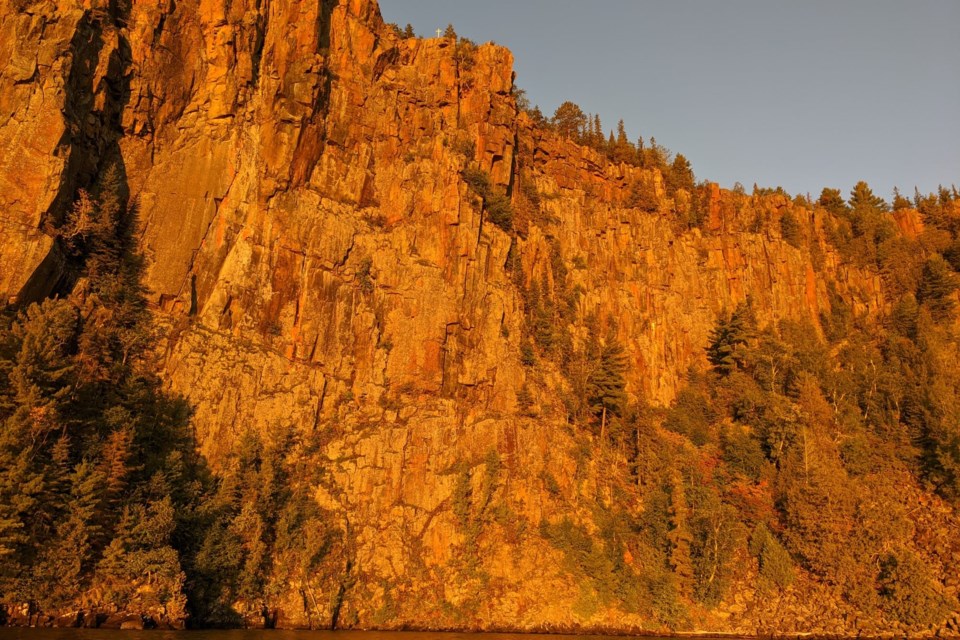
Seven – Devil’s Rock near North Cobalt, another “go to,” worth repeating. I have written about this too many times and have been a shameless promoter of this destination. See the video clip - I had hair then. One of the best vistas in northeastern Ontario, so easy to access. But you must see it from the top and from the water to appreciate its enormity (the bonus is a sighting at dawn – the cliffs become golden palisades). It should be our Niagara Falls terra firma of the north.
This summer, where will the back roads lead me?
I'm still trying to get to the Artery Lake pictograph collection, northwest of Red Lake, at the extreme end of Woodland Caribou Provincial Park near the Manitoba border. It is one of the best in Canada. And I want to see some Pukaskwa Pits near Red Sucker Point on Lake Superior, which has evaded me for quite some time.
So many locations to see and so much more to do. Google Back Roads Bill Village Media, there are hundreds of stories with destinations and here for some videos. You can contact me for advice. I'm glad to share the back roads.